Update: new developments in the antiquity sites in Silwan, the area surrounding the Temple Mount/Haram al-Sharif and in Hebron
In the past few weeks right wing settler NGOs have taken over new areas in Silwan/City of David, at the Davidson Center adjacent to the Temple Mount/Haram al-Sharif, and in Hebron (Tel Rumeida). In all these cases, the settlers’ hold on the new areas have been explained as being warranted due to security needs, development or the management of archaeological sites. In our opinion, when it comes to Silwan and the Old City, the developments only increase the tension in the area and raise concerns amongst the Palestinians that there are real attempts to change the status quo at the Temple Mount/Haram al-Sharif
The Davidson Center – Between Silwan and the Temple Mount/A-Haram a-Sharif
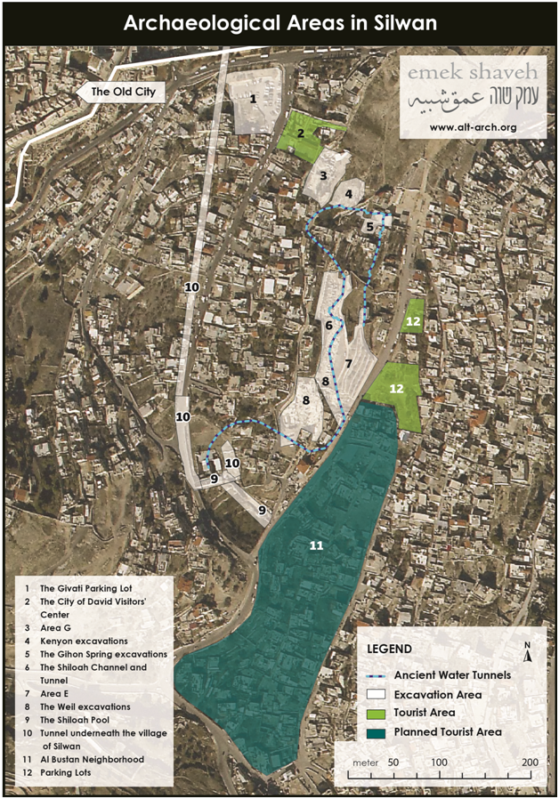
At the beginning of 2014, during the period when Uri Ariel (HaBayit Hayehudi (The Jewish Home party)) was minister of Construction and Housing, an agreement was signed between the Company for the Reconstruction and Development of the Jewish Quarter (which is under the ministry of housing) and the Elad Foundation to transfer the management of the Davidson Center to the Elad foundation.[1] The Davidson Center (no. 6 in map no. 1) is an archaeological site open to the public that displays the antiquities discovered in the excavations that took place all along the southern wall and part of the western wall of the Temple Mount/Haram al-Sharif. This is the largest area ever excavated in the Old City. Due to its sensitive location adjacent to and to the foot of the Temple Mount/Haram al-Sharif it had been decided in the past that its management must remain in the hands of government authorities.Uri Ariel (today minister of Agriculture and Rural Development), is the most right wing minister in the government and is known more than anyone for his struggle to change the status quo at the Temple Mount. As a minister of housing Ariel made statements about the need to build the third Temple.[2] In the present government Ariel is one of the most prominent politicians who ascends the Temple Mount. The Elad Foundation, for its part, never makes any statements about the Temple Mount and in the past has even distanced itself from some of the groups who promote renewing Jewish prayer on the Mount. Elad’s activity surrounding the Temple Mount focuses ostensibly only on archaeological activities. So, for example, the foundation funded the excavation of a tunnel which links the excavation area in the Givati Parking lot in Silwan (the southern part indicated as no. 10 in map number 1) to the Davidson Center. This tunnel ends right at the foot of the wall surrounding Temple Mount/Haram al-Sharif.[3]
Some of the tours to the City of David Visitors’ Center, which is operated by Elad, focus on the Second Temple Period and customs of pilgrimage. The central project around the Temple Mount, which the Elad Foundation funds, is the sifting project in East Jerusalem where soil from debris removed from the Temple Mount by the Islamic Waqf during development work on the Haram al Sharif between 1996-1999 is being sifted and inspected for ancient artefacts.[4] In April 2014, the state attorney’s office appealed to the court against the agreement between the Elad Foundation and the company for the Reconstruction of the Jewish Quarter and was successful in the magistrate court. But after an appeal tendered by the Elad Foundation to the district court Elad’s position was accepted and the court ruled to allow the foundation to take over management of the site. [5] We have yet to see whether the State will appeal the district court’s decision.
If the Elad Foundation takes over the management of the Davidson Center, they will be able to strengthen the connection between Silwan and the Old City through tours which link the two sites, and through the excavation of more tunnels and the creation of underground paths that will link the sites. The Kedem Center – the tourism center which the Elad Foundation is planning to build at the entrance to Silwan (no. 2 on map no. 1) is meant to serve as a center that will linkup the two sites. Assuming that Elad operates in the Davidson Center in the same way as it does in the City of David, then it is likely it will invest millions of shekels in archaeological excavations and the development of a touristic site that will represent history in a one-dimensional way, highlighting the Jewish story at the expense of other periods. Developing the site using archaeology, in the mode that Elad is known for, could increase tensions vis-a-vis the Islamic Waqf, and between Jews and Arabs at the most sensitive place in the region.
Silwan
During the past summer, the Nature and Parks Authority and the Elad Foundation began fencing in and placing gates around a touristic area, termed ‘Area G’ (no. 3 in map no. 2). This is an area of about 2000 sqm. adjacent to the City of David visitors’ center, which had been open to the public and accessible to the local residents since the British Mandate period. Until it was closed off it was possible to enter and exit the village of Silwan by foot through paths along this area. In recent weeks, gates were erected on paths leading to another archaeological area called ‘Area E’ (no. 7 in map no. 2). This area is located south of Area G and it is almost three times as big. It borders to the east with the al-Bustan neighborhood.
These two areas have been unofficially in the hands of the settlers and the Nature and Parks Authority for years, but they had been open to the public and used by the local residents of Silwan, one of the most crowded neighborhoods in the city. As one can gather from the map attached, closing them off will enable the Elad Foundation to control the paths and most of the area on the eastern slopes of the Wadi Hilweh neighbourhood in Silwan (the area which is also home to the City of David site).
The process of closing off a public space for the benefit of the national park, even if it situated near and inside a built up area, is characteristic of the way the Nature and Parks Authority and the Silwan settlers have been operating for two decades. In the middle of the nineteen nineties the village spring called Ein Um al Daraj/the Gihon Spring (no. 5 on map no. 2) was closed off for archaeological excavations and has not since been opened to the public. In 2005 the area of the Birkat el Hamra/Pool of Siloam was closed off (no. 9 on the map) on the southern end of the village adjacent to the al-Bustan neighbourhood. Since then one has to pay a fee to enter the site.
The effect of these changes on the situation in East Jerusalem, specifically with respect to the Temple Mount/Haram al-Sharif
In the last few years we have been witnessing growing activity of archaeological excavations and development for tourism in areas adjacent to the Temple Mount/Haram al-Sharif. The activities mentioned in this document alongside the excavation of the Western Wall Tunnels, which is ongoing, and the attempts to fence in the Bab al-Rahme cemetery ( see Emek Shaveh’s update on this from August and September) , shows how the area around the Haram al-Sharif is surrounded by settler activities that are creating sites that significantly strengthen the Jewish connection to the area. It is possible to claim that the activities adjacent to the Haram al Sharif’s walls are not related to the activities of the groups which ascend the Temple Mount or who are working to change the status quo on the precinct. But there is no doubt that creating an environment and engaging in activities which highlight the significance of the Temple Mount to the Jewish people, and the presence of religious groups characterized by a nationalistic Jewish ideology in areas bordering on the mosques have an impact on the atmosphere and tensions on the mount.
Tel Rumeida in Hebron
The archaeological excavation at Tel Rumeida in Hebron began in January 1914. Its purpose was to render the site as an archaeological park to be managed by the settlers of Hebron.[6] A few days prior to the intermediate days of the festival of Succoth (Feast of the Tabernacles) the civil administration people began to place signs at the site as part of its development for tourism. The signs (it goes without saying) focus on the history of the people of Israel and are written in Hebrew and English only. This step which is perhaps minor in the overall process of preparing the site, was undertaken despite the fact that a petition still stands in court against the allocation of the site to the settlers.[7]
When plans for tourism development for Hebron were presented by the Civil Administration in May 2015, it was said that the plan for the development of Tel Rumeida will be part of a new tourism project which will link several archaeological sites between the settlement of Kiryat Arba and the tel. There are plans to create walking trails for settlers from Kiryat Arba (from the site Khirbet a-Dir, which is situated in the area of the settlement) through to the Cave of the Patriarchs, to Tel Rumeida.
On the face of it, it seems that the development of the paths and the archaeological excavation is being undertaken by several different bodies. But it also seems that these projects cross-fertilize and compliment each other: the archaeological excavations provide the developers new areas to expand into, and the existence of a tourism project offers the archaeological site a wider historical and spatial context. In such a way Kiryat Arba and the settlement in Hebron will be linked physically (through the trails) and historically (through the archaeological sites).

Tel Rumeida photos:


[1] Press Release: [1] The Ministry of Housing acted against Attorney General in case of ‘Davidson Center’ in Old City of Jerusalem
[2] H. Ezra, Ministry of Housing: Build the Temple on the Temple Mount, Arutz 7, 4 July 2013 (Heb)
[3] Press release: Petition to transfer management of Silwan-Western Wall tunnel from Elad to the State , Emek Shaveh, 12 April 2015.
[4] R.Greenberg, Y. Mizrachi “Archaeology on a Slippery Slope: Elad’s sifting project in Emek Tzurim National Park”, Emek Shaveh, 2012.
[5] N. Hasson, “Settler Group Wins Right to Run Jerusalem Archaeology Park After Appeal”, Haaretz, 13 October, 2015.
[6] Y.Mizrachi, Tel Rumeida, Hebron’s Archaeological Park, Emek Shaveh, November 2014.
[7] High Court of Justice decision regarding archaeological excavations in Hebron—Tel Rumeida, Emek Shaveh, 5th January, 2015.
Back to top